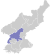
Yangdok County
Appearance
Yangdŏk County
양덕군 | |
|---|---|
| Korean transcription(s) | |
| • Chosŏn'gŭl | 양덕군 |
| • Hancha | 陽德郡 |
| • McCune-Reischauer | Yangdŏk-kun |
| • Revised Romanization | Yangdeok-gun |
 Map of South Pyongan showing the location of Yangdok | |
| Country | North Korea |
| Province | South P'yŏngan |
| Administrative divisions | 1 ŭp, 18 ri |
| Area | |
| • Total | 772 km2 (298 sq mi) |
| Population (2008[1]) | |
| • Total | 61,355 |
| • Density | 79/km2 (210/sq mi) |
Yangdŏk County is a kun (county) in South P'yŏngan province, North Korea.
History
[edit]The region is thought to be near the ancient chiefdom of dongye. Biryuguk used to be in the region. It was incorporated into Goguryeo around 40 BC.[2]
Climate
[edit]| Climate data for Yangdok (1991–2020) | |||||||||||||
|---|---|---|---|---|---|---|---|---|---|---|---|---|---|
| Month | Jan | Feb | Mar | Apr | May | Jun | Jul | Aug | Sep | Oct | Nov | Dec | Year |
| Mean daily maximum °C (°F) | −1.3 (29.7) |
1.9 (35.4) |
8.3 (46.9) |
16.1 (61.0) |
22.6 (72.7) |
26.3 (79.3) |
27.6 (81.7) |
28.2 (82.8) |
24.3 (75.7) |
17.8 (64.0) |
8.5 (47.3) |
0.4 (32.7) |
15.1 (59.2) |
| Daily mean °C (°F) | −8.1 (17.4) |
−4.4 (24.1) |
2.0 (35.6) |
9.0 (48.2) |
15.4 (59.7) |
20.0 (68.0) |
23.0 (73.4) |
23.1 (73.6) |
17.6 (63.7) |
10.3 (50.5) |
2.7 (36.9) |
−5.1 (22.8) |
8.8 (47.8) |
| Mean daily minimum °C (°F) | −14.2 (6.4) |
−10.6 (12.9) |
−3.9 (25.0) |
1.9 (35.4) |
8.4 (47.1) |
14.4 (57.9) |
19.1 (66.4) |
19.1 (66.4) |
12.2 (54.0) |
3.9 (39.0) |
−2.7 (27.1) |
−10.4 (13.3) |
3.1 (37.6) |
| Average precipitation mm (inches) | 9.4 (0.37) |
15.4 (0.61) |
25.7 (1.01) |
48.7 (1.92) |
80.0 (3.15) |
117.8 (4.64) |
275.8 (10.86) |
231.3 (9.11) |
94.2 (3.71) |
46.6 (1.83) |
41.5 (1.63) |
19.6 (0.77) |
1,006 (39.61) |
| Average precipitation days (≥ 0.1 mm) | 4.8 | 4.7 | 5.4 | 7.2 | 8.2 | 9.2 | 13.3 | 11.3 | 6.6 | 5.2 | 7.5 | 6.9 | 90.3 |
| Average snowy days | 5.5 | 4.1 | 3.2 | 0.9 | 0.0 | 0.0 | 0.0 | 0.0 | 0.0 | 0.1 | 2.1 | 5.9 | 21.8 |
| Average relative humidity (%) | 75.9 | 72.4 | 69.9 | 65.1 | 67.2 | 73.8 | 81.6 | 82.0 | 78.2 | 75.7 | 77.4 | 77.4 | 74.7 |
| Source: Korea Meteorological Administration[3] | |||||||||||||
Administrative divisions
[edit]Yangdŏk County is divided into one ŭp (town) and 18 ri (villages):
|
|
Transportation
[edit]Yangdŏk county is served by Yangdŏk Station on the Korean State Railway's P'yŏngra Line.
Yangdok Hot Springs Tourist Area
[edit]In 2019, Yangdok Hot Springs Tourist Area was a key construction project, built on the site of Yangdok Recreation Center which opened in 1947.[4][5] It was opened by Kim Jong-un on 7 December 2019. It featured indoor and outdoor baths, a ski slope, and a horse-riding park.[6]
References
[edit]- ^ Korean Central Bureau of Statistics: 2008 Population Census Archived 2010-03-31 at the Wayback Machine (Population 2008, published in 2009)
- ^ "평안남도 동부에 위치한 군" (in Korean). Retrieved 2023-09-03.
- ^ "30 years report of Meteorological Observations in North Korea (1991 ~ 2020)" (PDF) (in Korean). Korea Meteorological Administration. pp. 215, 309, and 344. Archived (PDF) from the original on 29 January 2022. Retrieved 24 March 2022.
- ^ Zwirko, Colin (28 June 2019). "Yangdok hot springs and ski resort project taking shape as October deadline looms". NK News.
- ^ 金正恩朝鮮労働党委員長が目指す「温泉大国」とは?. KoreaWorldTimes (in Japanese). 2019-11-17. Retrieved 2020-10-24.
- ^ Zwirko, Colin (8 December 2019). "Kim Jong Un oversees opening of Yangdok Hot Springs and ski resort". NK News.
External links
[edit]- (in English) Map of Pyongan provinces Archived 2012-03-11 at the Wayback Machine
- (in Korean) Detailed map

